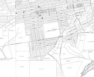
A map of Winston and Salem North Carolina – and the surrounding land as far as it was owned by the Congregation of the United Brethren, Salem, NC. Compiled from the Original Surveys by E.A. Vogler, Salem NC, 1876. This image is a re-tracing by Hinshaw and Ziglar Civil Engineering done in 1915 of the1876 original.
 Ever wondered about the West End and surrounding countryside before it was the West End?
To get your bearings, the “Y” just off center to the bottom right is now known as the fork of Burke & First, then known as Shallowford Street to the left and Shallowford Road to the right, which ran west out of town to the “shallow ford across the Yadkin River.”
The Paper Mill Pond in the bottom right of the map was one of the earliest in the state, dating back to 1790 (see www.historync.org). The remains of the pond-dam can still be seen where Academy Street (formerly known as Paper Mill Pond Road) crosses Peters Creek Parkway. Paper Mill Pond once filled the troughs below what is now known as West End South. £
Notice the small “Quarry” near the modern Intersection of Wachovia and Gregory on the other side of Peters Creek.
- Modern Westdate Avenue was “Nading” land.
- The modern baseball stadium lands were “Brietz” and “Hay” holdings.
- The Browns owned the tract between modern Burke and First
- The Walravens owned a tract across from later Grace Park
- The Fries family owned the vast majority of lands consolidated a few years later by the West End Hotel and Land Company, now known as “West End.”
